|
THE weather was exceedingly cold when we returned to the Republican River; we had not got a very good night's sleep, but when we got back to the river on the evening of January 21st, where the main command was, we felt more at home. We were better able to cook our rations, and enjoy more safety in the camp. That night was very cold; the sky was covered with clouds; it was too cold to snow, and ice was falling in little frozen pellets. General Mitchell had among his camp equipment a thermometer, and that night the thermometer went down below zero. We stayed up during the night alongside of the fires, to keep from freezing, and dozed a little. On the next day, January 22, 1865, we marched down the river nine miles into the last bunch, down-stream, of the big timbers; that was a hard day's march. During the day we were joined by all the parties who had been sent out scouting. They all found about the same conditions that we found on our scout. The Indians were flying and separating purposely so that it would distract pursuit, but they had some place where they were going to rendezvous again; at least that was a fact upon which all the guides agreed, and the question was whether or not we should go back up the Republican River. There was a great deal of discussion as to where the Indians might go. It was agreed upon by all that the big timbers had been their great rendezvous and that we had driven them out; but, where they had gone, or where they would meet again, was a problem. This matter of chasing the Indians was discussed a great deal over the campfires. General Mitchell's idea was that such terms of peace ought to be made with them as would put them upon reservations, and make them dependent, but yet would feed them well and clothe them well. General Mitchell's argument was something like this: "It is a well-known fact that it costs a million dollars a year to keep a cavalry regiment in the field. It takes in my district, from Omaha to South Pass, three regiments of cavalry; that is to say, three million dollars a year. This is outside of the loss of productive labor, and loss of men by death and disease." Then the General added: "I would put these Indians on reservations, dress them up in broadcloth, feed them on fried oysters, and furnish them money to play poker with, and all the tobacco and whisky they wanted, and then I will be a million dollars ahead of the game in my little district every year." Along in the afternoon of this day the weather began to grow colder and colder. The wind came down from the northwest with the fury of a cyclone, and it blew the ashes from the fire so that, although we had large log-heaps, we could only stay on one side of them with the wind blowing on our backs; we could only get warm by hugging the fire. As the night grew on it became dangerous to go to sleep. The horses were taken into the most sheltered part of the woods, and fires were built in log-heaps some little distance from the horses to the windward, so that the warmth would blow down onto them. Nobody went to sleep that night. The guards were changed every thirty minutes, and the men brought in. Guard duty was exceedingly severe, but had to be maintained. At 3 o'clock in the morning, General Mitchell's thermometer showed twenty full degrees below zero. The night seemed an intensely long one. Everybody kept in motion, nobody dared to go to sleep, and although we had log-heaps blazing, it seemed almost impossible to keep from being frost-bitten. Finally the wind ceased in the morning as the sun rose, and it rose clear and still. What such a streak of weather would do for the Indian fleeing across the country we could well imagine. It carried out Bridger's theory of the death of the women and children if the chasing of the Indians continued during a winter campaign. An Indian campaign in the winter is anything but pleasant. There is absolutely no fun in it. As there were but few trees up the river above the Big Timbers, and as the scouts all reported that the heaviest body of Indians seemed to have gone down the river, fleeing from our approach, we started the next morning, January 23, 1865, to march down the river. At headquarters a pail of water that had been brought up from the river to be used in cooking, but which had not been used, froze solid clear through that night. 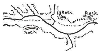 Route down the Republican. And that morning when we started out, our artillery crossed on the ice which had been frozen that night. The wagon-train also crossed to the south side on the ice. The men were in no condition to march, nor were the horses in very much better condition, but it was not possible to let up, and we were obliged to keep on the go; so down the river we went. A march of thirty-two miles brought us down below the mouth of White Man's Fork. Four miles down from the mouth of White Man's Fork was a stream called Black Wood Creek, before referred to, coming in from the north. The mouth of White Man's Fork was marked by five cottonwood trees. Up White Man's Fork clumps of scattered trees were seen for about eight miles. The mouth of Black Wood Creek was marked by an immense undergrowth, with trees on the side, probably all willow. Eight-Mile Creek, on the south side, had a dense undergrowth at its mouth, and a forest of large trees, probably cottonwoods, extending miles up its course to the south. The trappers said that Eight-Mile Creek was a great beaver creek. Below that a stream came in from the north with a few scattered willow bushes and cottonwoods on its banks. We crossed the river twice on the march, with our wagons and artillery, on the thick ice.  Map of Camp, January 23, 1865. We went into camp under some rock bluffs where the course of the river deflected northerly, and went up near the bluffs. Our camping-line at this camp, January 23rd, ran north and south. The rock bluff was limestone without fossils. There was a heavy growth of very large willows here, quite tall and some of them two feet in diameter, with very heavy underbrush of willows. From the mouth of White Man's Fork down to this camp was twenty miles, and the river-bend and the bottoms were about five miles wide, covered with high rank grass. We were in this camp about four miles up from the mouth of Red Willow. Some of the most splendid hay lands that we had seen in the western country were along the river. The roadway was very fine -- no heavy pulls. Wood was not very plentiful, but sufficient for any amount of overland travel. Above I give a map as I drew it of the route down the river. Lieutenant Talbot, a Nebraska man -- I have spoken of him before -- spied a lone buffalo, and killed it. As we came down, fire accidentally got out, and swept the bottoms smooth, and clear from bluff to bluff. The night of that camp was again very cold. In the heavy cold of the night before I had frosted two of my toes, and this night I frosted two of my fingers. We had plenty of wood. It was not as cold as before; fortunately it was still, and we dozed around the fire all night. The two fingers which I frosted were the two front fingers on my left hand. It annoyed me very much, but there was not a person in the command who was not more or less frosted. General Mitchell got his ears very seriously frosted. 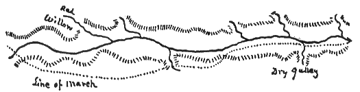 Line of march down the Republican River But there was nothing for us to do except to push on; so, the next morning, January 24, 1865, over the burnt landscape down the river we went, a direct distance of thirty miles; but, by the route we traveled, thirty-five. We camped down the river a little distance east of Medicine Creek. It was sometimes called "Medicine Lake Creek," from a lake on the west prong. The bed of the river all day long was all about a uniform width of two and a half miles. The grass lands, although burned, showed plainly, down the river as far as we could see, a very fertile valley; and there was wood enough all the way. Our route was a little north of east. We marched on the south side of the river all day. Above is a line of the march as taken from my map made that evening. 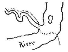 Republican River at mouth of Medicine Creek. As there was nothing to be found going east, we turned back January 25th. There was an island in the river just below the mouth of Medicine Creek, and avoiding the island we went across the Republican River on the ice, up Medicine Creek a little distance on the ice, and then came out on its east bank. We crossed the trains and artillery on the heavy ice. The stream was a very difficult one for us to march along, because its course curved backwards and forwards from bluff to bluff, and rock strata pointed out of the bluffs at several points. That day's march up Medicine Creek was twenty-four miles in a course north of northwest, and we went on bluffs or plateaus most of the way. The guides thought we would find Indians on the east of Medicine Creek. All this time the wind blew clear and cold from the northwest and the whole command led their horses until from time to time the command was given to mount, and then the horses would be run for a little while to get them warmed up, then the men would dismount and walk. And so we went, running our horses and then running on foot, all day. Riding against the wind was very unpleasant; all of us had our heads muffled up in the capes of our overcoats, and we kept our roadway by peering through openings in the folds of our capes. As we were riding against the wind we would look out through our capes with one eye. In a little while the tears of that eye would be frozen up, and vision entirely obscured; then we would shift our capes to the other eye while we warmed up with our hands and thawed the ice out from the other eye. We thus alternated all day, January 25th, and the result was that almost everyone frosted his eyelids. Mine got into bad condition, and every once in a while an officer would say to me as we rode along, "You will never see Omaha." In fact, whenever we got into any bad place someone was telling me that I would "never see Omaha." We crossed the Medicine twenty miles from our morning camp, and camped that night farther up in a valley, in a clump of timber which the Indians had been occupying shortly before. It was a most beautiful valley, where we camped, capable of irrigation and cultivation, and a stream came in which we named Mitchell's Creek, after General Mitchell. We made a total march that day of 26 miles, most of it in the face of a freezing wind. The place where the lake was is shown on the accompanying map. On this page I give the map exactly as I drew it that night. Medicine River forked, and we went up the east fork. The next day, January 26, 1865, we marched up the east fork of Medicine Creek, and made our noon halt within two miles of the head of the stream, a distance of twenty-one miles; thence we went up the stream, thence seven miles over the divide to the head of Cottonwood Canyon, then down Cottonwood Canyon twelve miles, and arrived at Cottonwood Springs at four o'clock p.m. after a day's march of forty-two miles. 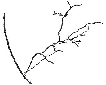 The route on Medicine Creek. It appeared to me that this last march of forty-two miles was the longest march I ever made in my life. The keen northwest wind, the hard riding, the want of sleep, the inability to properly cook our food, and the fact that not a member of the command escaped being frost-bitten, contributed to make it a march long to be remembered. An incident happened when we were camping on January 20th in the Big Timbers, which I ought not to overlook. We had been out six days on the expedition, and General Mitchell was afraid that he might be snowed up or frozen in somewhere, and thought it safe to have a train loaded with supplies of corn for the horses, and rations for the men, all ready at Fort Kearney so that it could start out for our relief on a moment's notice, on receiving word from a courier: the question was, how to get such a message back to Fort Kearney. There was a little red-mustached Irish sergeant, but from what command I do not know, who volunteered to make the trip if he could have a proper guide, and he would strike right out across the country to Fort Kearney. I think he belonged to one of the Nebraska Militia companies. There were a couple of Pawnees with us as guides, and one of these Pawnees offered to go across with the sergeant, and act as scout, and deliver him safely to Fort Kearney, provided that General Mitchell would give him a horse. The General promised to do this; the Indian had no horse; said he preferred to go on foot anyhow, and that he could keep up with the sergeant's horse all the way in to Fort Kearney. This was a sort of a funny proposition, and I remember looking at the long, gaunt, slim Pawnee, a young buck about twenty-three, and wondering whether he could keep up all day with the cavalry horse or not. Leo Palladie said that the Indian would hold onto the sergeant's stirrup-straps, and run alongside of the horse as fast as the horse could go, for a week. So the commissary issued them each four days' rations of bacon, hard-bread and stuff, and they were ordered to immediately get ready. They proceeded to cook up their rations; when they were cooked the Indian went to work and ate up every vestige of his four days' rations. He bolted down an enormous quantity of raw bacon, and he ate the other stuff as fast as it was cooked. The sergeant took an ordinary white man's dinner, and put the balance in his haversack swung onto his saddle, but as to the Indian, all he did was to buckle up his belt as tightly as he could get it, and start off on a trot alongside of the sergeant's horse and hold of the stirrup-strap. They started out after dark, and they both arrived at Fort Kearney, a distance of over a hundred miles in a straight line, on the afternoon of the second day. General Mitchell was sorely disappointed that we had not been able to find out where the Indians had gone, and what they intended to do. We had not killed a hostile Indian, and probably not less than fifty soldiers had to be discharged on account of freezings and injuries received on the trip. In addition to that, we had ruined about a hundred horses, and six wagons had been broken down and abandoned. The General, as we rode down Cottonwood Canyon, on the end of the trip, was quite melancholy, and all he could say was: "Well, what more could we do? What more could we do?" and he seemed disconsolate over the fact that there was not an Indian less, and he keenly felt the distress which his men had suffered. He was constantly referring to the "poor fellows," and how bravely they had stood the weather, and how awfully cold it was, and what enormous marches had been made under such suffering conditions. And then the General would get moody; and say that, while the war was going on down South, here he was fighting Indians; that there was no glory in it, and when the war was over all he could pride himself on was his former service down in the Southern Confederacy. That when he would reflect as to what good he had been to his country, he would say that he hadn't been any good while he was out in the Indian country. He said that he would make an application to be sent down to fight where there was some glory, and if he couldn't get it he was going to resign; that he would not have any more Indian-fighting in his military history; that this trip had demonstrated to him that he was no Indian-fighter, and that there was no glory in it, and the Government was wasting money in paying him a salary for trying to look after the Indians. It was really distressing to hear the General talk. I rode with him in his ambulance down Cottonwood Canyon, and as I was his aide-de-camp he talked to me in a very free and kindly way. As I had seen him after he was carried off from the battle-field at Wilson Creek, wounded, and had referred to it, he said that he had lots rather go down South and be shot to death than to stay up North and fight Indians and be frozen to death. And that although his superiors might order him to make another Indian campaign for the purpose of keeping the Indians moving, he was going to have a command farther south or else leave the service. The General soon after sent in his request for a detail farther south in the theatre of the war, or else that his resignation be accepted. A recapitulation of the trip is as follows: It had lasted from January 15, 1865, to January 26th, inclusive, being twelve days. The men of my company had marched, owing to the side-trip they took down into Kansas, more miles than the Expedition had marched, and more than any other company had marched. The record of my company was as follows: |


