|
WE WERE now on the west bank of the Medicine River. The stream as we viewed it from the northeast was the arc of a circle marked by a high line of ragged bluffs. The march that day had been a cold and severe one. Indian signals had been noticed during the night, and from time to time in the distance we saw smoke signals, and some of the scouts saw at a distance some straggling Indians. In fact, from long distances on both sides of us the Indians were viewing and sizing up our expedition. Of course, the more they saw of it the less they would want to tackle it. We were sort of groping our way through the country; but we wanted to get in west of the Indians and drive them east and cut them off from retreat to the mountains and the north. The bugle called us at 5 o'clock, and we were all up and ready to start, January 17th, as soon as it was daylight. We crossed the ridge west of our camp, marched one mile southwest by west, came to a dry ravine filled with scattered trees, thence southeast a half-mile, when we struck a stream. The main canyon running west was narrow, with high banks in which was cottonwood timber. It was marked for about a mile with springs, which formed the stream; above them the canyon was dry. We moved up this canyon about two miles, where it forked into three prongs. We took the left one running southeast by south, followed it up three-quarters of a mile, and came upon the plateau by a gradual slope. Without much work we made a road through the ravine and canyon, that was good. This canyon would have made an excellent place to camp. Up on the plateau we marched about three miles east of south, then about two and a half miles west of south; then we marched southerly ten miles, gradually swinging around to the west until we struck the Red Willow. When we struck the Red Willow we were marching due west. We struck the stream at a place where there was a large clump of trees in a bend of the stream that made a reverse curve. The following is a diagram of it: 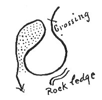 Red Willow Crossing. We found the old trail crossing two hundred fifty yards above where a ledge of rock jutted out over the stream, but it was too difficult to fix up and make passable, so we did not cross here. It was evidently an old buffalo trail, much traveled by the Indians, and all right for ponies, but it could not be utilized by our wagon train, so we went down the stream three miles farther. At this old trail-crossing was a clump of timber where an Indian camp had been, but which had been deserted a short time before. The guides said the camp could not be over a month old, and might be newer. On this day's march, January 17, 1865, we saw observing Indians far in the distance, but we only got glimpses of them, and they disappeared so that we could not tell which way they were going. But as we went scouting through the country, several of us who had field-glasses and good horses, rode up on all the highlands in the neighborhood to scan the horizon with our glasses. This camp on Red Willow had been a large Indian camp, and the indications were that they had gone down the stream. The three miles which we went down the stream from the old trail-crossing were along deep buffalo trails, cut wide, and we followed these trails until they struck the stream. We utilized this buffalo trail across the stream, and in a short time with picks and shovels made an excellent crossing. In fact, if it had not been for these buffalo trails we would have had a great deal of trouble; the banks of the stream were very precipitous, and it would have delayed us much to have had to make wagon-roads across. But where the buffalo trails had worn down the banks, we made a good crossing without very much difficulty. Four miles down the stream from this crossing, on the other side, we camped. From our camp down on the Red Willow as far as we could see, the cottonwood timber along the stream was very dense. The stream was sunk about four hundred feet below the level of the plateau, and along the stream were signs of great Indian camps. We had evidently got right into the country where the Indians lived, and where they had their permanent villages. We could see where they had been cutting down the limbs of the cottonwood trees for their ponies to browse on, and the grass was pretty well eaten off around in the neighborhood. There were many large cottonwood trees lying on the ground. The weather was very cold, and we chopped up these logs, and snaked them around with mule teams so as to get them in position, and we cooked supper and sat around discussing Indians until we crept into our tents at night. We had marched that day about 22 miles. We emerged on the morning of the 18th from the canyon at the mouth of which we had camped, and went on southwest, leaving the river. There was an endless succession of sandhills. These hills had just enough clay in their composition to keep them from blowing entirely away; and they supported a slim lot of grass and weeds. On our left was a chain of ragged sand-bluffs. The road was rough on account of the many branches and ravines that struck it perpendicularly every quarter- or half-mile, many of them almost impassable. Our route was a succession of digging. We had to keep back as far as possible towards the sandhills, and we had to make a crossing at every ravine. During this day's march three wagons broke down, showing the rough treatment which they had received in going across these ravines. An army wagon for Indian service had to be made out of the very best kind of stuff. It had to be made from old, well-seasoned timber, which in turn had to be kiln-dried before it was put into the wagons, otherwise, out on the plains, during the dry and cold weather, woodwork would shrink. Once in a while a wagon had been made of timber not sufficiently seasoned. This would be discovered upon a march such as the one we were on, and then great trouble was occasioned by it, because the wheels had to be taken off, and thrown in the stream overnight so as to soak and swell up, and this occasioned work and delay. If the wheels were not kept tight, the wagon was bound to collapse under the hard usage which it had to sustain. As we were eating up rations and horse-feed rapidly, the three broken wagons were left as empties. The wheels and some of the woodwork, however, were distributed through the train to furnish repairs in case of trouble. This day's progress was only ten miles in a straight direction, but our journey was fifteen miles; we made a good road as we went. We crossed Blackwood Creek and a bad ravine going in a very crooked southwesterly course. Camped on the south side, where water was standing in pools. 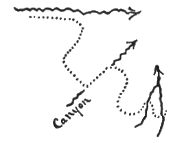 Dotted line indicates route to Blackwood Creek. The recent presence of large bands of Indians was noticeable, but there were none to be seen except an occasional scout far distant. The day's march, with few exceptions, ran on high ground. On the morning of January 19, 1865, the cavalry started out ahead of the train. We did not believe there were any Indians who would attack the train, and as a few of the men were badly mounted, their horses having shown signs of weariness, they were left back with the train and a piece of artillery. We made a dash across the plateau a little south of west, headed for the big timbers of the Republican River. A march of twelve miles, about ten miles in a straight line, brought us to the L'eau qui Peaue. That was a French phrase, and it was called briefly, "Lo-ca-po." The translation of it from the French name is borne on the modern maps as "Stinking Water," but the old name of Lo-ca-po should have been retained. We struck this stream two or three miles above its junction with White Man's Fork, went down its east side, and crossed the "White Man" below the junction. At the time we struck the Lo-ca-po its volume of water was twenty-four feet wide by sixteen inches deep, with a velocity of three miles per hour. The main stream of White Man's Fork had a width of eighty feet, by two feet deep, with a velocity of three and a half miles an hour. The Indian name for White Man's Fork was Wah-Seecha Wocca-pella. A short distance below where we crossed, a stream came up from the south called Ten-Mile Creek, which was small and impassable. Along the "White Man" at this point there were high bluffs on the south side, and a short distance down the river below our crossing the rock jutted out of a bluff and the river ran up under it at its base. The name of the stream is from the Sioux language. In that language Wah-Seecha means "white man." "Seecha" means "bad," and "Wah" means medicine; therefore a white man was, in Indian parlance, "bad medicine." We then came in a southerly direction up on top of the plateau from the bed of the stream, and after about five miles of travel came to the head canyon of Ten-Mile Creek bent around to the west. This we crossed, and kept on to the Republican, our course from White Man's Fork being west of south. I give all these names as they were then used by traders and guides. I do not know present names. In going across the upland upon this march, the advance guard, with which I happened to be marching, right at the highest point came onto a skull. It was the skull of an Indian and was very much decayed. Skulls upon that high, dry, hilly country lasted for a great many years. This one looked very ancient. It might have been a hundred years old. The skull had an iron arrow-point penetrating it from the upper side, the parietal region, entering the skull about an inch and a half. The arrow on the outside was almost rusted away. No other bones were visible. It was probably the relic of an ancient combat. We struck the Republican five miles below the upper end of the "Big Timbers," near a stream, and camped one-half mile below. The distance from White Man's Fork to the Republican would be about twenty miles direct, but by our line of march it was twenty-five. A short distance above where we camped was a most excellent place for a fort; the contour of the country and stream was as follows. I give it from the drawing I then made: 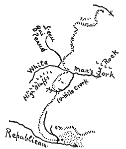 Route to the Republican River. The distance we marched that day, January 19, 1865, was thirty-seven miles, and the line of march was principally on high plateaus. We made splendid time, and it was fine scenery, and everywhere we saw signs of Indians. The trails were running in every direction. They seemed to be coming and going, backwards and forwards over the country, but nevertheless we saw none of the Indians except a few fugitive scouts. General Mitchell directed me to prepare recommendations for the establishment of a fort at the place just above described. The details were as follows: On the bench of land above where we camped the stream came into the Republican, with a curve from the north. Up along the stream above the junction was a beautiful level table, with bluffs high and rough but well back. The streams were very heavily timbered with cottonwood, and the little one came down through a ravine filled with heavy cottonwood timber as far as we could see. This table was about a quarter of a mile wide, and ran up the river about two miles. The bluffs were about a mile from the edge of the Republican river, and a fort there would be fully thirty feet above high water, and surrounded on three sides with water and difficult, abrupt banks. It was stated by the guides that the "Big Timbers" at the Republican practically ceased five miles above this place. The big timbers were enormous cottonwood trees that were along the Republican in and around here. Above them there were only scattering trees on the river. These trees finally ran out into nothing, towards the west. Nine miles below this place the big timbers almost entirely ceased, so that this camp was in the very midst of the big timbers. These big timbers were therefore about fourteen miles long, and filled most of the bottom-lands. There were several springs coming in at this place, and on the edge and through the timbers were dense growths of grass. The guides told us that this camp was about thirty-five miles below the "Ree Fork" (that was the common expression for Arickaree) and thirty miles up from the mouth of "White Man," but I think that this estimate of distance by the guides could be only guess-work. Above this camp five miles, and ten miles on the north side and ten miles on the south side, streams came in from the hills. These big timbers were all cottonwood trees averaging and exceeding two feet in diameter, and located on an average of about one to every fifty yards square, without a particle of underbrush, but a dense growth of high bottom-grass. Here was where the buffalo used to live, and here we found Indian signs everywhere prevalent. The location of the Big Timbers was as follows: 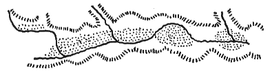 Big Timbers on the Upper Republican River, fourteen miles along the stream. From this camp in the big timbers scouting parties were sent out to see if we could find the Indians. Very great numbers of them had been hibernating through the heavy timbers scattered along the river at this place, and the question was where had they gone. Joe Jewitt had been brought along, and he was sent out in one direction to guide a party; Charley Elston was sent out in another direction; Leo Palladie was sent out in another. The latter command consisted of most of my company, and I went with them. We were sent southwest to go across the plateau, and follow a tree line which ran up the south fork of the Republican River, and then go south to the headwaters of the Sappa rivers. There were then the North and South Sappa; now the north one appears on the map as Beaver Creek. Sappa, in Sioux, meant "black." These creeks were full of beavers then. We started, and as we came near what is now the Kansas line, Leo Palladie, who was riding with me at the head of the company, looked up and surveyed the landscape, and said: "We are now in Kansas. We have crossed the line, and we are not very far from the northwest corner." As we rode up to the plateau he pointed to the west, and said: "There is Ree Fork. You see where it strikes that other stream? Well, that high ground on the other side is across the line. The northwest comer of Kansas is up near where those two streams come together." I asked him how he knew, and he said that one time he was going over the country with some Indians and a white man who knew about the survey, and the white man pointed out to him where the northwest corner stake of Kansas was driven. It was not far from the water-bed of Ree Fork. We went up onto the plateau. The country was as poor and arid as it could be on the upland; there was grass growing on the bottoms. Looking some little distance ahead, I saw a hill which was split down from the top like a Bishop's mitre. I said, "What hill is that?" and he said, "That is a sandhill." As it was in our course we soon reached it, and there I found a large hill of sand, through the middle of the top of which the wind both ways (north and south) had excavated the same, and spread it over at least a half-mile square on the north and south sides of the hill. I asked Palladio how that could happen, and he said: "Well, it happened like this. Deer are very curious animals, and the old bucks do guard duty for the herd, and give signals of danger. These bucks will go up on the tops of the hills, and will wear out with their sharp hoofs, while stamping off flies, whatever coat of grass happens to be there. Perhaps a single file of buffalo have gone over the top of the hill, as they are prone to do. Then the winds come and get a start, and hollow it out." This hill was a very large mound, and the excavation which the wind had made was one in which vast quantities of sand had been carried away. During the whole scout we had seen in the far distance from time to time, single isolated Indians. In one case, off at a distance of perhaps three miles, we saw a pony running with a lodge. The Indians place a lodge-pole on each side of a pony, allowing the ends to drag, and upon these ends place their tent and equipment, and it goes over the ground dragging as fast as the pony can go. We got down into Kansas at what would now be called Sherman county, went into camp on a little stream, and the next day returned to the Republican river, making about 100 miles in two days. We found nothing in the nature of a large trail. The trails were all small, but very numerous, seeming to indicate that the Indians had scattered every-which-way, each one for himself. The difficulty of this condition of things was that we could not scatter out ourselves, and follow the individual trails. The Indians in all directions had scattered out like a fan. They probably had some place arranged for meeting again, but we could not follow those tactics. We had to keep together, and be ready for them upon all occasions. There was a large migration Indian trail coming from the southwest, but it appeared several months old. One of the other scouting parties that went west had a different experience from ours. They were up amid a nest of timber, had taken a wagon along with tents, and at night went into camp, but with due precaution they had their horses tied up closely in camp all night. But a body of Indians, not large in number, ran through their camp at night, shooting off firearms, breaking tent-ropes and pulling up pegs, but doing no damage. No soldier was injured nor an Indian hurt, and they went off in the dark night as rapidly as they came. Although the soldiers had guards out, the guards could give no intelligent account of the matter. |


